
Page 56 - navstrat
P. 56
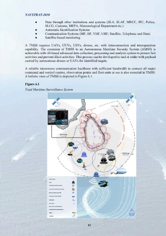
NAVSTRAT-2030     NAVSTRAT-2030

 ●   Advanced  Surveillance Systems.  SLN is  to be  equipped with  state-of-the-art   ●   Data through other institutions and systems (SLA,  SLAF, MRCC, IFC, Police,
 maritime  surveillance  systems,  including the newest radar  systems,  Unmanned   SLCG, Customs, MEPA, Meteorological Department etc.)
 Aerial Vehicles (UAVs), underwater detection and analysis sensors and vehicles,   ●   Automatic Identification Systems
 Automatic Identification Systems (AIS), Global Positioning Systems (GPS), Vessel   ●   Communication Systems (MF, HF, VHF, UHF, Satellite, Telephone and Data)
 Monitoring Systems (VMSs), satellite surveillance facilities, to improve real-time   ●   Satellite-based monitoring
 situational awareness. The High-Frequency Surface Wave Radar (HFSWR) system
 on the Eastern  coast served immensely  to  apprehend vessels  conducting  illegal   A  TMSS  requires  UAVs,  UUVs,  USVs, drones,  etc. with  interconnection  and interoperation
 activities in the long-range beyond the coverage of typical radars in the past. The   capability.  The  extension of  TMSS to  an  Autonomous  Maritime  Security System (AMSS)  is
 introduction of similar mechanisms to other areas towards South East, South and   achievable with AI-based advanced data collection, processing and analysis system to protect licit
 Western coasts will enhance real-time detection capabilities further. However, this   activities and prevent illicit activities. This process can be developed to raid or strike with payload
 process has to commence subjected to careful study of the existing system and its   carried by autonomous drones or UAVs for identified targets.
 utilization at present and future.
                   A reliable microwave communication backbone with sufficient bandwidth to connect all major
 ●   Data Fusion and Analysis.  The establishment of a robust data fusion and analysis   command and control centres, observation points and fleet units at sea is also essential in TMSS.
 centre  to integrate  information  from various  sources  has  enabled a  quick and   A holistic view of TMSS is depicted in Figure 6.1.
 informed decision-making process. This  mechanism will enhance  with  full
 functioning of existing IFC and MRCC by acquiring equipment and sensor nodes   Figure 6.1
 for surveillance stations, main units, sub-units and platforms. Interconnection of   Total Maritime Surveillance System
 those systems  is  possible only  through  adequate  data,  telephone  and other
 communication  network  facilities  including  MF, HF,  VHF, UHF and  satellite
 communications means. Integration of AIS, Automatic Vessel Locating System
 (AVLS), GMDSS, updated electronic charts and mapping data, human intelligence
 and sharing information with local, foreign and multinational institutions will easier
 this process.

 ●   Under Water Detection Capability.  The increasing power rivalries in the IOR,
 require the necessity of having underwater detection capability for major ports in
 the country and platforms. Frigate with ASW capability would be the best option
 for platforms for this purpose. Due to the financial constraints, instead of high-end
 sonar systems;  affordable dipping sonars, towed  array  sonars  or  unmanned
 underwater vehicles will serve the purpose.

 ●   Hydrography and Oceanography.   Considering the large sea area belongs to
 the country, hydrography and  oceanography  surveying capability  is  another
 concern of SLN and SLCG. Hydrographic and Oceanographic survey platforms
 with multi-beam echo sounders  will serve this  purpose. The introduction  of
 surveying equipment onboard ships/craft as feasible is another option at the early
 stage.

 Total Maritime Surveillance Solution

 A Total Maritime Surveillance Solution (TMSS) is an integrated, comprehensive solution designed
 to monitor, manage and control maritime-related activities covering the maritime domain of the
 country. This total solution consists of the following to ensure safety, security and to have real-
 time situational awareness and reaction;

 ●   Surveillance using coastal sensors (Radars, HFSWR, High-resolution day and night
 cameras, Underwater detectors)
 ●   Surveillance using sensors onboard fleet units
 ●   Human and Maritime Intelligence
 ●   Weather and Environmental Sensors


    42                                                          43